Mapping public transport in Belgium
Open Street Map is a crowd sourced map which can be reused by anyone. You can for example look up the Brussels North station, and see how all bus stops, platforms, railway tracks are shown with a very good precision.
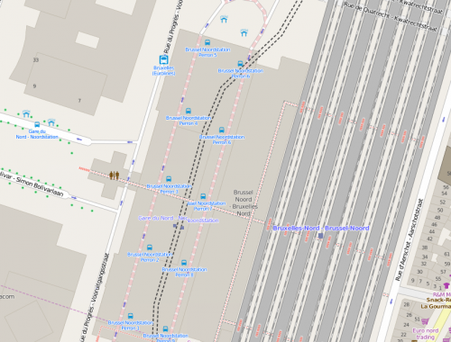
The Brussels North Station in Open Street Map
This is not a coincidence. We have a very active Open Street Map Belgium community (just as iRail, it is part of Open Knowledge Belgium), that is working on integrating existing datasets with Open Street Map, and correcting errors when they see them. Polyglot wrote a very nice article which explains better what the workflow is.

Belgian volunteers add the data of NMBS/SNCB in the maps of Open Street Map
If you would like to start reusing the open transport data within Open Street Map for your project, you can always get in touch with the guys at osm.be. A nice place to start is downloading a dump of entire Open Street Map over here: http://wiki.openstreetmap.org/wiki/Planet.osm
Pieter